![](/images/other/stat-length.png)
![Randonnée Marche La Bourboule - Rocher de l'aigle-cascade Vernières-rigolet-cascade Pardon - Photo](https://media.geolcdn.com/t/1900/400/73fa2d29-a45a-4ebd-853d-8468679653ae.jpg&format=pjpeg&maxdim=2)
Rocher de l'aigle-cascade Vernières-rigolet-cascade Pardon
v.rabot
Utilisateur
![Longueur](/images/other/stat-length.png)
![Altitude max](https://static1.geolcdn.com/siteimages/upload/files/1508320355ic_sort_altitude_max_24dp.png)
![Dénivelé positif](https://static1.geolcdn.com/siteimages/upload/files/1508320355ic_sort_den_pos_24dp.png)
![Km-Effort](/images/other/stat-length.png)
![Altitude min](https://static1.geolcdn.com/siteimages/upload/files/1508320355ic_sort_altitude_min_24dp.png)
![Dénivelé négatif](https://static1.geolcdn.com/siteimages/upload/files/1508320355ic_sort_den_neg_24dp.png)
![Boucle](https://static1.geolcdn.com/siteimages/upload/files/16400158638029165_repeat_loop_refresh_sync_direction_icon.png)
![Marche](https://static1.geolcdn.com/sitytour/trail-icons/101.png)
5h00
Difficulté : Difficile
![Scannez ce code QR pour ouvrir la randonnée dans l'application SityTrail](https://capi.geolives.com/qq0zvz2zws4bq2lad0pu/sitytour/trails/2973667/qr.png?size=200)
Application GPS de randonnée GRATUITE
À propos
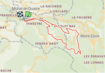
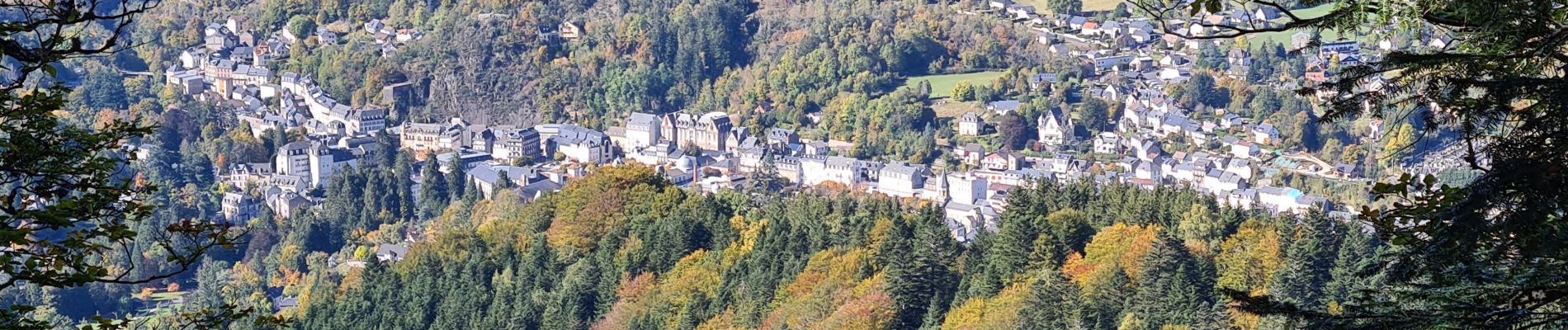
Randonnée Marche de 18,5 km à découvrir à Auvergne-Rhône-Alpes, Puy-de-Dôme, La Bourboule. Cette randonnée est proposée par v.rabot.
Description
Partant du pont de la Dordogne le circuit traverse le village de la Bourboule, passe au Pregnoux et monte au rocher de l'Aigle, c'est la partie la plus difficile. Passé cette montée, il y aura un petit coup de collier à donner pour admirer la petite cascade de la Verrière, On redescent sur Rigolet le Haut, on passe à le Buron, Sagnove pour redescendre sur le Pregnoux en passant par la cascade du Pardon. Retour sur la Bourboule
Localisation
Commentaires
Randonnées à proximité
![Randonnée Marche Saint-Sauves-d'Auvergne - St_Sauves_Chateauneuf - Photo](https://media.geolcdn.com/t/375/260/5b40d0cb-0279-49d3-aedd-b2d33d081712.jpg&format=jpg&maxdim=2)
![Marche Marche](https://static1.geolcdn.com/sitytour/trail-icons/101.png)
Marche
![](/images/other/stat-length.png)
![](https://static1.geolcdn.com/siteimages/upload/files/16400158638029165_repeat_loop_refresh_sync_direction_icon.png)
![Randonnée Marche La Tour-d'Auvergne - Tour_Auvergne_Chambourguet - Photo](https://media.geolcdn.com/t/375/260/89f1026c-dcfd-4eec-ac48-a164d692d4ad.jpg&format=jpg&maxdim=2)
![Marche Marche](https://static1.geolcdn.com/sitytour/trail-icons/101.png)
Marche
![](/images/other/stat-length.png)
![](https://static1.geolcdn.com/siteimages/upload/files/16400158638029165_repeat_loop_refresh_sync_direction_icon.png)
![Randonnée Marche Murat-le-Quaire - De Murat le Quaire au Puy Gros - Photo](https://media.geolcdn.com/t/375/260/ext.jpg?maxdim=2&url=https%3A%2F%2Fservices.sitytrail.com%2FGeolivesWS%2FDownloadMedia.ashx%3FTrailID%3D173047%26Media%3D14567_5.jpg)
![Marche Marche](https://static1.geolcdn.com/sitytour/trail-icons/101.png)
Marche
![](/images/other/stat-length.png)
![](https://static1.geolcdn.com/siteimages/upload/files/16400158638029165_repeat_loop_refresh_sync_direction_icon.png)
![Randonnée Marche La Bourboule - Bourboule_Vendeix_Charlannes - Photo](https://media.geolcdn.com/t/375/260/974b84fb-245b-4e5c-88f2-976a8059b2eb.jpg&format=jpg&maxdim=2)
![Marche Marche](https://static1.geolcdn.com/sitytour/trail-icons/101.png)
Marche
![](/images/other/stat-length.png)
![](https://static1.geolcdn.com/siteimages/upload/files/16400158638029165_repeat_loop_refresh_sync_direction_icon.png)
![Randonnée Marche Murat-le-Quaire - Murat_Quaire_Ordanche - Photo](https://media.geolcdn.com/t/375/260/b09d93ea-88df-4f42-8ffa-b565d95a8b44.jpg&format=jpg&maxdim=2)
![Marche Marche](https://static1.geolcdn.com/sitytour/trail-icons/101.png)
Marche
![](/images/other/stat-length.png)
![](https://static1.geolcdn.com/siteimages/upload/files/16400158638029165_repeat_loop_refresh_sync_direction_icon.png)
![Randonnée Marche Murat-le-Quaire - La Banne d'Ordanche - Photo](https://media.geolcdn.com/t/375/260/ext.jpg?maxdim=2&url=https%3A%2F%2Fservices.sitytrail.com%2FGeolivesWS%2FDownloadMedia.ashx%3FTrailID%3D147717%26Media%3D20120817123608.jpg)
![Marche Marche](https://static1.geolcdn.com/sitytour/trail-icons/101.png)
Marche
![](/images/other/stat-length.png)
![](https://static1.geolcdn.com/siteimages/upload/files/16400158638029165_repeat_loop_refresh_sync_direction_icon.png)
![Randonnée Marche Murat-le-Quaire - Banne d’Ordanches - Photo](https://media.geolcdn.com/t/375/260/d96c37de-8bd1-4492-8cba-24f6951ae64e.jpg&format=jpg&maxdim=2)
![Marche Marche](https://static1.geolcdn.com/sitytour/trail-icons/101.png)
Marche
![](/images/other/stat-length.png)
![](https://static1.geolcdn.com/siteimages/upload/files/16400158638029165_repeat_loop_refresh_sync_direction_icon.png)
![Randonnée A pied La Tour-d'Auvergne - Chambourguet - Photo](https://media.geolcdn.com/t/375/260/cae5925b-61ac-47d4-b021-c5bfebecd2dc.jpeg&format=jpg&maxdim=2)
![A pied A pied](https://static1.geolcdn.com/sitytour/trail-icons/100.png)
A pied
![](/images/other/stat-length.png)
![](https://static1.geolcdn.com/siteimages/upload/files/16400158638029165_repeat_loop_refresh_sync_direction_icon.png)
![Randonnée A pied Saint-Sauves-d'Auvergne - De la Dordogne aux volcans - Photo](https://media.geolcdn.com/t/375/260/ae8fc4f5-d959-4ad2-96df-a2429d0f6cda.jpeg&format=jpg&maxdim=2)
![A pied A pied](https://static1.geolcdn.com/sitytour/trail-icons/100.png)
A pied
![](/images/other/stat-length.png)
![](https://static1.geolcdn.com/siteimages/upload/files/16400158638029165_repeat_loop_refresh_sync_direction_icon.png)